Showing posts with label PA Horseshoe Trail. Show all posts

Saturday, November 19, 2022

PA Horse-Shoe Trail: Brecknock Loop East

 #36 2022 52-Hike Challenge:  Brecknock Township Bldg/ HST/ Alleghenyville Rd Loop - 5.5mi

While Northwestern Pennsylvania was hammered with yesterday's lake effect snowstorm, the Iron Hills of Berks and Lancaster County received a fairy dusting of snow. It was windy and cold atop the ridge as I walked along the yellow-blazed Horse Shoe Trail east from the Brecknock Township Building where I left my truck in its own designated HST parking space.


Ridgetop cornfield

The HST exists along this ridgetop because private landowners allow it to and we hikers are reminded of this with frequent warnings via "Stay on Trail" signs, "No Trespassing" signs, boundary-marked spray-painted trees, game cameras and even a CCTV (all with "You are Being Watched" notices). This close to firearms season it is very wise to wear blaze orange, which I did. Tree stands are all up ready for the start of next week's deer hunting season. So, I moved pretty quickly through the few miles of trail before intersecting with the narrow road that would loop  me back to the truck.


Snow dust


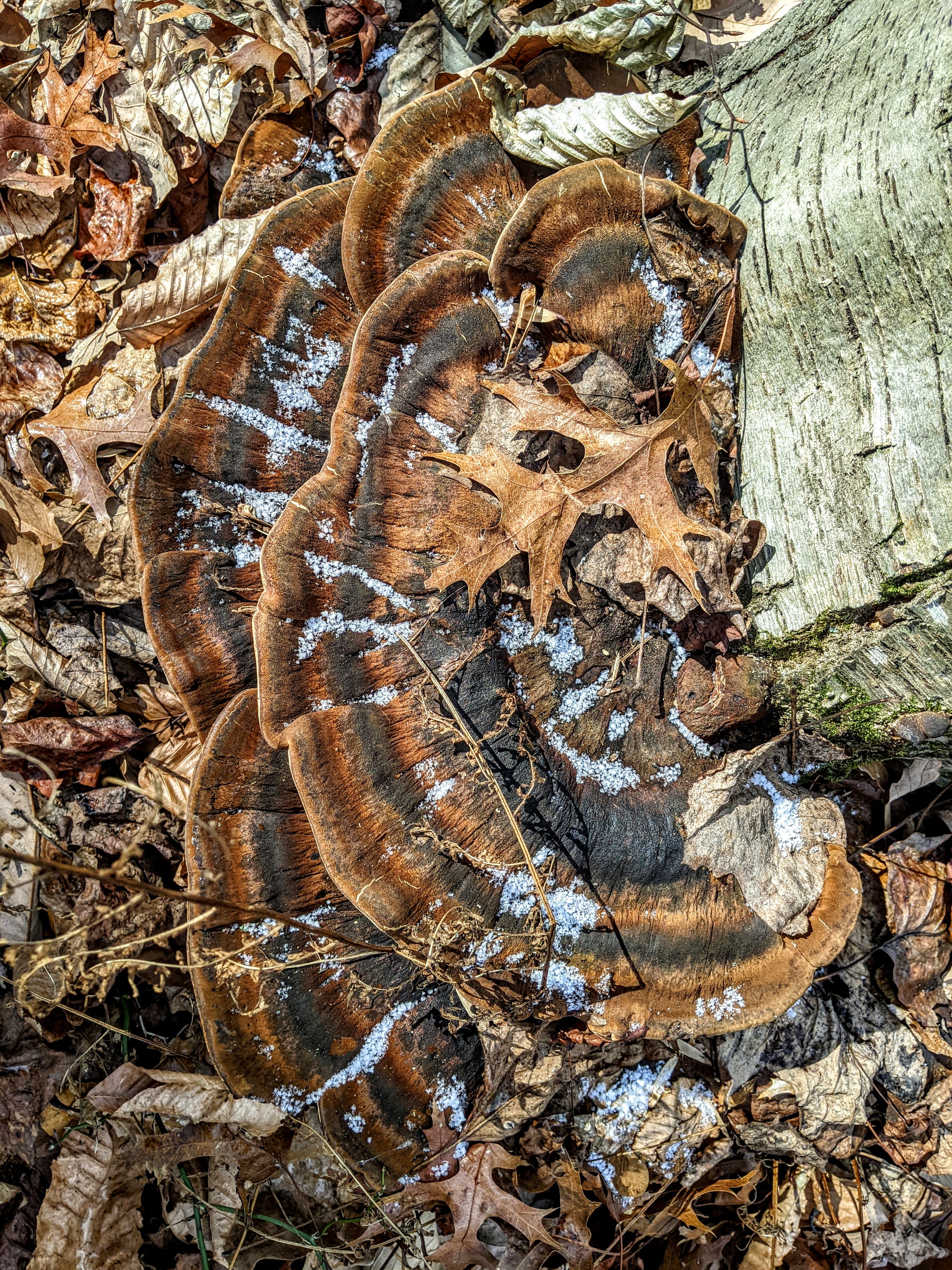
Bracket Fungus

This ridge is laid open with the occasional cornfield planted now in winter wheat. Field stone piles of red sandstone nearly as tall as me were the work of settler farmers and the generations of farmers who followed them. Stone fences line much of the trail and in a few places cut through them. It is hard to imagine this windy ridge clear of its forests, but from the 1700s onwards much of the Iron Hills region was deforested for farming and logged for building and the iron furnace charcoal industry. These mature forests are less than a century old. 


Virgin's Bower, Clematis virginiana


Miles of stone fence


Leaf-covered trail

I had to pay close attention to the blazes and my map. With all the leaves on the ground now, the path is almost invisible. I was following an old road covered in leaves at one point, pretty easy going, when I  met up with a group of three hikers who warned me about the section I was about to enter. "The landowner is not friendly to hikers," one hiker said. "Don't stop for any reason." 


Stone fence crossing


The old road soon became festooned with "No Trespassing" signs and warnings "You Are Being Watched." Really a shame, I thought, as this section was one of the prettiest sections of my hike today. Of course, a clump of snow dusted Bracket Fungi caught me eye right on the path. I pulled out my phone to take a picture and "CRACK-BAM!" a rifle went off just at the top of the hill where a house stood. I think that shot was my warning to keep going. 


Can you see the next blaze?

I decided to cut my loop hike a little short and took the next road to take me back to Alleghenyville Road and the walk back to the township building. I'll finish this loop another time, hopefully sooner than later. I am really itching to finish this years' long section hike of the Horse Shoe Trail. 


Sunday, October 23, 2022

PA Horseshoe Trail: Map 4 - Bucks Hollow (Dreaded) Road Loop

 #31 2022 52- Hike Challenge:  Horseshoe Trail, Berks Co. Bucks Hollow Road Loop / 6mi. 

Road walking

I couldn't decide whether or not to count this road walk towards my 2022 52-Hike Challenge, but given the history of the Horse-Shoe Trail which has significant portions on-road, I went ahead and counted it. I also really struggled with even doing this section because I hate road walking. I can't think of any long-distance hiking trail that doesn't have at least some road walking, however. So on this drizzly morning I thought what the heck, just get it done so I can eventually make it back into the woods. Maybe the rain will keep people home and I won't have to take my life into my hands, I thought. Turns out, I thought correctly. I didn't die.


Early 1700s log cabin (Beaver Run)

1800s school house

You really can't go too far in Berks County without bumping smack into historic structures. On this little loop I counted about a dozen structures - barns, log cabins, a school house, colonial-era farm houses, and an iron furnace (later). Thankfully I could stand safely off the road shoulder just about anywhere and not break any laws or get smashed by a car. Compare that to an earlier SHT road walk when I got yelled at for stepping into a driveway (private property) so as not to get smashed by a box truck. 


Ample shoulder 

The drizzle kept up as I topped the hill out of Buck Hollow but then the skies brightened a little once I made the off-HST turn towards Weaver's Tree Farm and Orchards, again very lucky that I was able to walk the farm road safely around and above busy Rt. 10. Sporting my blaze orange vest and orange baseball cap (thanks Keystone Trails Association!) I was very visible to oncoming traffic down Weavers Road. So visible in fact that two different people pulled up along side and asked if I needed a ride to beat the rain. Very nice, thank you, but no. One of those kind drivers was a long-time resident of the little community at the top of Quaker Hill Road and she told me how she remembered how the "old" Horse-Shoe Trail used to come right up her road and how she enjoyed meeting the hikers. Now the trail has been re-routed (thankfully) on to state forest land and though she knew it was safer that way she misses saying hello.  


Love me some Bully-Mack!

Weaver's Orchard

Weaver's Farm


The loop continued up and around Quaker Hill Road to Timber Ridge and then down to Overlook Road through older and newer neighborhoods. A kid tried to sell me some pink lemonade from her little stand at a yard sale. I don't carry cash, I'm sorry. She frowned at me and I frowned back. Looking at Map 4 I could see how  both of those roads were HST routes. Down the hill to come again to the log cabin and I turned back on to Buck Hollow Road for the lollipop section back to my truck at the state forest parking area.  


Back down Buck Hollow Road

New parking area at Buck Hollow Tract, William Penn State Forest


Having walked only six miles I had some extra time to go check out the Joanna Iron Furnace just a few miles south on Rt. 10. No one was there so I wandered aimlessly around the picnic grounds, demonstration area, and furnace structures. Everything was locked up tight but the deep red ironstone masonry was worth admiring. Two different building styles can be seen at the old furnace: the original cold blast stack and casting barn built in the 1790s, and the Engine House built to house the Weimer Blower Engine that replaced the billows and water wheel. It was looking rather a cross between Gothic Revival and a tad Victorian. What a stark difference in styles between the two! 


Joanna Furnace, 1791 - 1898

 
The original Joanna Furnace 


Finally done with this road section, I can stop gritting my teeth and look forward to a wooded stretch on my next hike approaching the boundary with Lancaster County. Looking back, this is one of those long distance trails that, like the Mason Dixon Trail my hiking pal Kim and I took four years to finish, is close to home. I think I started this trail in 2016 and so I am still going, a few sections and loops a year. 
There is so much great hiking in our region that the idea of road walking just puts me off, so I haven't been as serious about getting the HST done - like the MDT that had so much road walking. I'm only on Map 4 out of 10 so I guess I'll be doing this one for a few years more, LOL. 


Notes:

Joanna Furnace is maintained by the Hay Creek Valley Historical Association. They have several big events here throughout the year including a very popular Christmas weekend. This was not one of their busy weekends, however! https://haycreek.org/joanna-furnace/


Horse-Shoe Trail Conservancy maintains this 140-mile-long trails that links Valley Forge to the Appalachian Trail. It's taking me forever to complete it. https://cart.hstrail.org/home/

Sunday, March 6, 2022

PA Horseshoe Trail - Bucks Hollow to Six Penny Creek Loop

No Amos along today. Reading through comments on the Horseshoe Trail FB page for this section had me a little concerned about property dogs, both loose and contained, as well as a local gun club that has of late been very active. It lies close to the trail and is precisely where Amos turned around for an out-and-back from Scott's Run Lake when he heard shots fired. He doesn't do gunfire which is probably why he was dumped as a puppy being a gun shy hound. 


Pelvic bone of a Whitetail Deer - notice mouse gnawings.

This is #7 of my 2022 52-Hike Challenge which started at the brand new parking area on Buck Hollow Road for the William Penn State Forest.  Walking towards our turn-around point at Six Penny Creek and the gun club entrance I planned to make a loop via Geigertown and Hay Creek Roads to the (also new) state forest kiosk on Hay Creek Road for 12 miles. 


Brand new! 

The Horseshoe Trail depends largely on the good will of private property owners allowing hikers to traverse their land. Though the trail association has worked diligently over decades to foster good relations, there are some owners who challenge agreed upon permission-of-thoroughfare with intimidation and threats. As soon as the trail exited state forest land I was met with a No Tresspassing sign planted firmly in the middle of the path and I wasn't sure whether to continue. .   


Right in the middle of the trail...


Ribbons and wires laced the trees on either side of the trail. The sound of constant gunfire coming from a target range nearby made my decision to a walk around the sign a little nerve wracking, but I did. The trail blazes are freshly painted and the path well cared for and I had just watched a mountain biker blow past the sign, so I did too.  As my hike progressed, I was amazed at the amount of boundary marking whether with sometimes intimidating signs or blue/white/purple painted trees, including more wires and flagging tape augmented by the not-so-subtle signage indicating that surveillance cameras were in use.


...and all around the place. 

Once past the stretch of private property - evidently a logging tract - I was able to really enjoy the landscape with views through the bare trees towards French Creek State Park and the rolling hills all around.  Hay Creek flows in the valley and comes with its own historical association! This is the Iron Hills region, a long stretch ragged terrain that offered colonists abundant supplies of iron ore from Valley Forge to the Appalachian Front. The Horseshoe Trail never leaves the geology and history of iron production for its entire 140-mile length. Hiking historians, rejoice!


Brocade moss on red sandstone


Hay Creek Valley and French Creek State Park hills beyond.

The hills are pitted with small stone quarries and surface mines. I was surprised to see almost every large boulder along the trail with evidence of hammered star drills and feather-and-wedge splitting. For a while the path follows a narrow stone boat road where heavy horses pulled wooden sleds (called "boats") loaded with blocks of red sandstone to building sites in the valley. From the large stone dumps masons dressed and shaped the stone with hammers and chisels for building projects. One doesn't need to go far from the trail to see examples of fine red sandstone barns, homes, mills, and the nearby Joanna Furnace. I imagined the hills ringing with the sound of hammers on iron drills and wedges, very musical and a lot of work!


Hammered star drill and feather-and-wedge split stone (late 1700s)

Star drill holes and split faces


Check out this demonstration of star drill and feather-and-wedge stone splitting - truly a lost art! There are a few other nice demos on YouTube but remember that colonial stone splitters didn't have power tools so ignore the use of air compressors. The art of the stone splitter relied on listening to the changing sounds of metal in rock to determine the correct amount of force to make a clean break. This is the "music to my ears" way of hammered splitting.  


I made my way down the quarried hill and crossed over Hay Creek Road to follow a dirt road that crossed the creek. I stopped to listen to a chorus of newly arrived Red-Winged Blackbirds on a cattail marsh, visited with some cattle and goats, and got barked at by a few farm dogs whose tails were happily wagging to see a hiker cutting through the farm.  I had a chat with the farmer, a strapping woman my age, who offered me some tea from her thermos and a donut! That made up for all the angry No Trespass signs earlier on.


For my Camino friends who are going on pilgrimage this spring

HST is a NRT

Across the Pottstown and Railroad cut the trail climbed the next hill. It too was studded with surface quarries and split stone was everywhere. So was the sharp crack and bang of gunfire coming from the nearby gun range. Trying to speak with a couple and their remarkably calm Treeing Walker Coonhound was futile so we said our goodbyes. 


Iron bridge over the Pottstown and Reading RR cut 


Had the offer of tea and a donut visiting this bunch! 

The rocky trail wound around the hill intersecting with a maze of popular mountain biking trails contained in the Birdsboro Preserve. A trail crew was out working on planting a new sign to warn bikers off the HST. There are dozens of Preserve trails for bikers here but they persist in trying to use the HST.  Almost on cue I encountered two bikers pushing their bikes up the boulder strewn trail, frustrated that "this trail is shit" when it really wasn't made for mountain biking.  After a steep descent to Geigerstown Road, right next to the gun club parking area, I was exactly where Amos and I had turned around last time we were on the HST. This time there was a brain-rattling amount of gunfire. I am so glad I did not take him along. 


Finally on Geigerstown Road at Six Penny Creek

Part RR graveyard, part steam engine collection.

Wrecker crane - now a wreck on its own.


The road walk back to the state forest entrance on Hay Creek Road was pretty interesting but also pretty dangerous. I wore my brightest colors just for this portion of the walk as blind curves, no shoulders, and rolling hills made getting along with speeding cars pretty important. A few miles on the hardtop and I was blissfully back on the path to retrace my steps up into the Buck Hollow Track of the William Penn State Forest. 


Wintergeen

Buck Hollow Tract entrance on Hay Creek Road - loop complete!

Woods road back to the car

I've been making my way up the HST for a few years now, slowly but surely. I'm at a third completed on a northwest track to intersect with the Appalachian Trail. It's possible to do a big loop using the AT, HST, and Mason Dixon Trail with a connector between Valley Forge and Chads Forge on the Brandywine Trail. 

Today's loop included 8 miles on the HST and 4 road miles


Here's my hiking video for the day. You can get a feel for the background noise - it was either geese or guns. Amos would have lost his mind... (BTW you can find my videos at my YouTube Channel "Roamin' Bones" and while you are there, please subscribe!)


Notes:

For a look at the nearby Joanna Furnace (and the impressively beautiful red sandstone buildings) see the Hay Creek Valley Historical Association  https://haycreek.org/joanna-furnace/

Learn more about the National Trail  System  https://www.nps.gov/subjects/nationaltrailssystem/index.htm and in particular the National Recreation Trail System  https://www.nps.gov/subjects/nationaltrailssystem/national-recreation-trails.htm

Horseshoe Trail interactive map https://cart.hstrail.org/trail/

Tuesday, October 26, 2021

PA Horse-Shoe Trail: Map 1 Valley Forge to Chester Spring - What is "Natural?"

When I first started this blog many years ago, I asked what is natural in the Mid-Atlantic? Given that this region has been so long settled and industrialized, and at one time, deforested to the point of unrecognizable, I thought what is natural about any of it? Twenty years ago when I discovered the Horse-Shoe Trail I began hiking it mainly as a connector to other trails and I honestly didn't care for it. Until I began to look at it through the lens of environmental history, however, it has since helped me detangle the idea of what natural could mean for this region. So here is my HST hike through Map 1.


Trailhead marker near Washington's HQ, Valley Forge, PA

What I don't like about the HST:  Some stretches of dangerous road-walking; cutting through housing developments and backyards - where clearly the neighbors want to keep you contained to the 24" wide path; the persistent threat of closure should a property owner decide they no longer want the path on their land. 

What I do like about the HST: The dedication of the organization and its volunteer trail crews for its maintenance and fostering good relationships with property owners;  its storyline of American industrial history-turned-natural natural history; its accessibility for everybody.

Parade grounds at Valley Forge - now Eastern Meadow and Shortgrass Prairie

This day I walked 15 miles from the HST official starting point near General Washington's HQ in Valley Forge near Philadelphia.  This is where the trail is most accessible to public transportation and visibility, where a lot of folks discover it and then say "Well darn! I'm gonna walk the whole thing!" (Somebody actually said that to me when I was crouched down taking a photo of the plaque.) Point of note, however, the best parking to walk this section is a mile further into Valley Forge National Park at the large car park under the watchful gaze of General von Steuben. But it's an easy walk and a great opportunity to observe the tremendous effort that the National Park System has invested in ecosystem restoration. 

Springhead that supplied the Colonial Bottling Plant.


Following the yellow blazes, I hiked up the steep old road that climbs Mt. Misery and observed  foundations and cleared flat areas where buildings once stood. The ruins of the bottling plant stand hard along the road, easy to explore. It faces faced a stream that has suffered terrible erosion from the recent flooding caused by Hurricane Ida. No matter how thoughtful the park service has been in allowing the mountain and meadows to return to more natural states, however, the human impacts that drive rapid global warming cannot be ignored. Every stream I crossed or looked at today was severely gouged and gullied. 


Bottling plant ruins and flood-wracked stream

Colonization and industrialization have transformed this land over hundreds of years but even before the first colonist set foot here, this land was managed by the Lenni Lenape, transformed with fire, agriculture, quarrying, and modifications to streams and rivers to funnel fish into pens and weirs. I stopped at the top of the mountain to give silent acknowledgement to them. 


Valley Creek, once industrialized and polluted, suffered heavy storm damage from Ida.


Yellow blazes mark the Horse-Shoe Trail

Refreshed yellow blazes and posts clearly marked the path all the way to my end point. I rarely pulled out the map. Even a detour was marked well enough all I had to do was follow a new set of (blue) blazes, unfortunately all busy narrow roads. When the trail re-entered the woods, I was reminded of the use of trees for charcoal throughout colonial period until the late 1800s. I tried to imagine the forests cleared of their great Oaks and American Chestnut, that in their charred state fueled fifty or so foundries, kilns, and forges that were on or near this path all the way to its terminus at the Appalachian Trail 120 miles on.  


The starting bell.


Crossing the Valley Forge NHS boundary on to private lands.


I didn't take pictures of the many fenced or gated backyards, posted with signs so that HST hikers don't stumble into private property.  The idea of privately owned land was something new to the native people who were pressed further and further west, south, even north to make way for new owners.  I passed a country club, a retreat, a private park - all clearly marked with keep out notices. 


Must make a tour reservation!


Past the Warton Esherick Museum, which I have always wanted to see. Wharton was a leader of the Studio Crafts Movement in the early 20th century. I studied his work when I was in art school and have always wanted to build/create my own studio as he did, literally carved from the woods around him. As I glanced back at his home and studio I couldn't help but notice the nicely forged strap hanger that holds the sign, a necessary piece of a blacksmith shop's forge equipment. Esherick and his wife split their time between this home-studio in the woods and a socially progressive community, Fairhope, in Alabama.    


Historical marker down the road from the museum.

They both held to the idea of common use resources and lived at Fairhope as a single-tax property that included studios, workshops, cottages, and schools. Of course, they were shunned for their beliefs in social progressivism by anti-communists (many Pennsylvania artists, writers, craftspeople were) in the 1940s and 50s. Many social progressives fled Pennsylvania to escape political pressures and suspicion during the McCarthy Era. I tried to keep one eye on traffic and the other on my surroundings. I wondered about the use of the forest by craftsmen and, whether making utilitarian objects or artworks, if Esherick's creative progressive process wasn't part of the regenerating woodlands he surrounded himself with. 

A small community land commons.


I think I love Esherick's  wood cuts more than anything and how they remind me of wood fiber and grain emerging as image and object. Wood grain on paper made of wood pulp, they feel as intricate as woven bark baskets.  As a collector of few wooden bowls and baskets, I know that these items do not survive well in the archeological record and as I add a Gullah-made saltwater marsh grass basket or a turned Sassafras burl bowl to the table for Sunday dinner I think about how carefully these items were made and by whom. 

What you need to road-walk parts of Map 1 of the HST


Small patches of community conservation land provided safe haven from the perils of modern transportation. Some of these are small woodlands are barely enough to sustain habitat for non-human residents. I moved a Box Turtle out of the road.  I saw plenty of White-Tail Deer both in people's yards and in the patches of woodlands. I know that the Coyote has made the transition to suburban life when I found a few well-placed piles of scat full of rabbit and squirrel fur. The maze of roads and yards makes for poor habitat connectivity.  


Skirting a farm to avoid a road-walk.

Skirting a field to avoid a road-walk.

Skirting a pasture to avoid a road-walk.

Connectivity to culture and ecology are two important threads in weaving together a sustainable landscape. I can't say that hiking this section of HST was my most memorable hike with the (sarcastic) bonus of extra road miles due to the trail closure and long road detour, or twisting my knee stepping off a curb in a parking lot. But I could see that the landscape holds variations of its human and natural history well though out of balance.  I thought about one of Walt Whitman's great celebratory poems Song of the Broad-Axe and the implications for our natural heritage he wove into and out of the poem his take on American "progress." The hills here hold all of this as landform, some degraded, some restoring. "The shapes arise!" Whitman calls - and the land responds. 


Woodcut book plate by Esherick (1924) for Broad-Axe


I read the shapes of grown-over tennis courts, ankle deep with leaves and fallen limbs. The lumps and bumps of old foundations and sunken hollows of cellars and well pits dimpled the land. An old railroad slid  through the woods. Stone bridge abutments and little dams peek out from under vines and moss. Even some of the homes, once posh and expensive in their day, sit abandoned in the woods seem to be overtaking any attempt at making order of it.  I passed the now closed Great Valley Nature Center (sad!) and the meadow scrub that is now its parking lot. Shapes are rising!


Abandoned railroad in the woods.

Walking through this tangled landscape of plants and pavements, the question of what is natural seemed even more elusive. Here in the Mid-Atlantic invasive species like Chestnut blight, Spotted Lanternfly, and Tree of Heaven threaten the fabric of native ecosystems. But native habitats were long ago radically changed by centuries of industrial and agricultural use.  I picked up ticks on a stretch of pipeline right-of-way thick with invasive Stiltgrass. It is late October and there has yet to be a killing frost. As I sat on a rail of the disused railroad picking them off a White-Tailed Deer wandered by fat from feeding in backyards and gardens. 


Lawn ornament in the woods. 


The road walking and a sore knee finally got the best of me just two miles from my meeting place with a friend who offered to take me back to my car at Valley Forge. I was creeping along and the afternoon sun was already long in shadow. I can walk for days on natural trail but I am no good after a few hours on pavement. I called and she picked me up from a construction site that will soon hold million-and-a-half-dollar mansions on what was once cropland, that was once pasture, that was once charcoal woods, that was once berry meadow grazed by elk. 


What do you think endures?
Do you think a great city endures?
Or a teeming manufacturing state? or a prepared constitution? or the
best built steamships?
Or hotels of granite and iron? or any chef-d'oeuvres of engineering,
forts, armaments?
Away! these are not to be cherish'd for themselves,
They fill their hour, the dancers dance, the musicians play for them,
The show passes, all does well enough of course,
All does very well till one flash of defiance

- From The Broad-Axe, by Walt Whitman


Beggartick


Notes:

Purock Spring Water/ Colonial Bottling Plant a brief history by Mike Bertram, Tredyffrin Eastown Historial Society: https://tehistory.org/hqda/pdf/v47/v47n3p084.pdf

A lecture on Wharton Esherick, presented by Mark Sfirri:  http://www.raymondfarmcenter.org/sfirri-wharton-esherick-lecture

Walt Whitman's Song of the Broad Axe  from the Walt Whitman Archives:  https://whitmanarchive.org/published/LG/1891/poems/91