Saturday, March 8, 2025

PA York Heritage Rail Trail - Segments 5 & 6

 Segment # 5 - Brillhart Station to Howard Tunnel (March 2 2025) 4.5 miles O&B


16 miles to go!

A bright but colder day, Amos and I completed a 4.5 mile out-and-back starting at the YHRT parking lot at Brillhart Station to make the historic Howard Tunnel our snack break and turn around point.  As we walked past the old station house (now a private residence) and the small Brillhart trackside community, Red Tail Hawks were circling and calling over the Codorus Creek valley. Their courtship calls filled the next mile of rail trail walking and was a welcomes sign of spring on this chilly day. The tracks curved around bends ahead following the creek closely.


Amos sunning

Near an outcrop of phylite (metamorphosed shale, sand, and mudstone) the sun heated up the forested curve like a greenhouse and Amos decided to pause for a sun soaking. He does love sunning. I explored the outcrop while he warmed up and found some star bit drill tracks including a horizontal bore hole. These were made by hammering hand held drill bits into the rock that allowed for blasting sections of wall away to make room for the double rail line. The North Central Railroad (NCRR), first run in 1838, connected Baltimore with York and was a vital link for transportation and transfer of goods for over 125 years. 


Drill trace

Horizontal bore hole

This famous rail line was one of the first to radiate out from the Baltimore in a network of lines that connected Philadelphia, New York, and industrial cities during a time of capitalistic expansion in the 1830s. By mid-century, the NCRR was a busy rail corridor and a target of Confederate attacks to derail northern supply lines. As we approached the historic Howard Tunnel I could see clearly the hilltop outpost above the rail line where Federal troops maintained a cannon and guard station. 


Going through the Howard Tunnel

A fault line and a Union outpost

The brick-lined tunnel marks a place where the Martic Overthrust Fault Line can be seen as it runs nearly up against the tunnel opening and stone facade. This Alleghenian era fault line marks the crustal boundary of two continents that smashed against each other 320-million years ago, a line that runs all the way to Long Level on the Susquehanna River and across into Lancaster County. This is the fault that gives us the Wind Caves, a tectonic plate shift cave in PA, currently one of the Lancaster Conservancy's unique preserves.   


Dressed stone 

Slickensides of vertical fault line tracks

Overthrust fault boundary at tunnel entrance


This system of faults shows up in several places in York County including in Emigsville Codorus Stone Quarry near where we started this Walk with Spring. The Martic Fault runs in a SW to NE line from southern York County beyond Quarryville in Lancaster County.. It is visible in other railroad cuts as well, namely the Enola Low Grade Rail Trail across the river. It serves as clear evidence of how collisions of tectonic plates buckled, folded, and finally broke to shear up and over other masses of rock, actions that formed entire mountain ranges in the Eastern U.S. 

Vertical phylite outcrop

A cold air vent with teeth 

Original NCRR mile marker for Baltimore


After having a snack at the tunnel, reading the historical panels, and enjoying the tranquility of this preserved landscape we made our turn around. On the way back I noted a few fractures in the outcrops where deep cold air gaps appeared to have teeth of ice. Those warm outcrops of near vertical phyllite rock slowed Amos again and though he didn't sit down, he slow-walked this section to soak up as much warmth as he could. An original NCRR mile marker indicated southbound trains had another 52 miles to go before pulling into the Baltimore station.


Codorus Creek 


Sec. 5 (4 mi) yellow, Sec 6 (7 mi) green


Section #6  Seven Valleys to Howard Tunnel Out-and-Back, 7 miles

The South Branch Codorus Creek was never far from the winding path of the North Central Railroad on this section of the YHRT and to our delight it was filled with sounds of spring with Wood Frogs, Spring Peepers, and a Barred Owl sighted not far from what appeared to be a nest cavity in a sycamore along the edge of the stream. I neglected to bring my binoculars but if I squinted hard enough I was able to see the bobble head of an owlet inside as she shifted back and forth to look back at me and the dog.

South from the Howard Tunnel

We're starting to make friends with the regular walkers and riders of the trail as we recognize each other along the way. Today a bicyclist stopped to ask how far we've come so far and I figured we're at or just past the half-way point over these past few weeks of out-and-backs. He rides the entire trail every week (40+ miles) and so has been the one to call out "Amos!" on his way by. 

Fine quartzite with embedded biotite crystals

Tiny little things

 
Several outcrops of phyllite, quartzite, and schist frame the railroad cut through the woods and while there is some folding and faulting, not as dramatic as Section 5 (above). The biotite crystals were cool though! In a little hillside springhead green grass and bright yellow-green watercress blanketed the ground adding a splash of color to the otherwise earthy brown hillside of dead leaves and bare woodlands.

Glatfelter Station 

The original 1750s Glatfelter farmhouse marks the nearby crossroads where the Glatfelter Station once stood, an important local stop for this valley full of farms that delivered dairy products north and south on the freight trains. The creek meandered all across the wide valley and with so many oxbow ponds tracing older channels of the stream, it seemed all there was to hear was Wood Frogs and Spring Peepers in all their courting songs. 

Broad valley hemmed by Antietam Quartzite ridges


Seven Valleys park and rail trail access

Amos let me know many times on this section that I'd forgotten both his water and his little bag of kibble treats. When we arrived back at the Seven Valleys parking area he put on a dramatic show of needing to get to his forgotten treasure by yowling at the bike sculptures. No time for pictures, just get him to the truck! 


Sunday, March 2, 2025

PA York Heritage Rail Trail: Spring Hikes - Segments 3 & 4

Segment #3 : Loucks Mill Road Parking to York Colonial Complex (Feb 26, 2025) 4 mile O&B

In a time when our attention spans generate someone else's profit, salary, and sales, it's good to turn off the device and notice what's around you. What a beautiful day to make this walk into the city. The Canada Geese have paired off now and both Bald Eagles, nesting nearby, were seen circling Codorus Creek. A woman carrying her finds bag was mud-larking along a gravel bank. A kind old gentleman with a permanent smile on his face and pep in his step outpaced Amos and me as my dog stopped every thirty feet to sniff. 

An adoring hound

We came to a full stop at the side of the old armory building, now a beautiful creative learning and museum. Amos was drawn to the sounds of children inside and he could see them through the big glass windows. Oh! He loves kids so much. He whined and wagged and sat right down hoping he'd have the chance to say hello. They were busy making something cool at a work bench so we moved on down the rail trail as it entered the city. 


Keystone Kidspace in the old armory

Western Maryland Railway

We crossed over the Codorus and past the historic WMRR railyard depot house. My great grandfather was one of the founding investors of this railroad in the late 1890s (he lost his shirt on it) so I said "Hello Pops!" to the station yard as we walked by. Past the old switching yards and double steel span RR bridge, a family out for a stroller stroll asked if their little boy could pet Amos and this made the coonhound's day. 


Keystone Color Works

The old Keystone Color Works building, now studio apartments, stands as a monument to what had been a source of Codorus Creek's major pollution problems - wastewater of the paint and dye industry. The effluence from paper manufacturing, dyes, and paints was so obnoxious, city residents called the creek "Inky Stinky." Thank goodness that era is over. A ways further and what's left of the historic 19th century Variety Iron Foundry site is across the river, now a restaurant and outdoor events space. This was once a huge industrial site that manufactured steam train engine components, rails for the railroad, cast iron building fronts, gears, bridges, turbines, and factory equipment. 


Foundry site

York History Center


The tall stack across the street dominates the scene along this stretch of the rail trail. Now the main building of the multi-structure York History Center, this complex was once the Edison Steam Generating Plant that helped electrify the city at the turn of the century. We arrived in the heart of the transformed industrial center of York where factories and plants once crammed the shorelines of the creek to make this city a manufacturing powerhouse.


Barnett Bob House (c. 1830s)

Kitchen garden, Golden Plough Tavern

Golden Plough Tavern (1741) and Gen. Horatio Gates House 

Colonial Courthouse (1754) and the Second Continental Congress 


Our turn-around spot was the Colonial Courthouse where the Articles of Confederation were approved during the nine-month 1777 congressional escape from Philadelphia as the British were bearing down on that city. From the safety of the west shore of the Susquehanna in York, the documents approved here were then sent on to the states to be ratified. The Articles of Confederation unified our new nation so that we had the weight of law and the beginnings of a strong congressional government to wage war against the King. Hmm. That's an idea that needs revival. 

This document, the first version of the Constitution, would remain in effect as a framework for how the United States of America would function and thrive until the 2nd Constitution took effect in 1789. I had the distinct feeling that our Founding Fathers would be gasping in disbelief if they were around today to see what has become of us. 


Seg. 3 yellow / Seg. 4 green


Segment #4:  Brillhart Station to York College (Feb 28, 2025) 6 .5 mi O&B

I waited until I'd wrapped up my work work before heading out to do this next segment of my Walk with Spring on the York Heritage Rail Trail. It was a gorgeous afternoon and for a Friday, the trail was almost empty except for a few dogs and their humans. We walked north along the packed gravel path through beautiful countryside, between sections of newish suburban neighborhood, and into York. At York College we spun around for the return trip.


Coming into Hyde


Scrap yards in York


Above Indian Rock Dam Road


This stretch of trail had a little bit of everything, but what it had mostly was active Groundhog dens where our furry marmot friends were stretched out in the sun, scratching and grooming, and generally giving Amos none of their business.  We walked on the high RR embankment above Codorus Creek, where just downstream is the 1942 Indian Rock Dam constructed to help control flooding in downtown York. In 1933 York had experienced catastrophic flooding - this is no coincidence during the time half the country was in drought and the Dust Bowl occurred. Climate instability works at the extremes. The dam was put to the test in 1972 when Tropical Storm Agnes dumped an ungodly amount of rain in Pennsylvania. It was the only time the spillway has ever been used. It worked. The dam and flood control system is now over 75 years old and we wonder how much more it can withstand as these kinds of flooding events happen regularly now, hence, all the work being done here and in York to bolster an aging system. 


Snowdrops 


I spied my first flowers of spring as we passed little clumps of Snowdrops along the railroad ballast bank. These flowers came to the U.S. with European immigrants who moved to this area to establish farms and homesteads in the 1700s. German was the most used language in York County until WWI when it fell out favor due to loyalty tests. It is still a predominant language in our county, however, and no matter what some ridiculous Executive Order says about English I'll just enjoy the Schneeblum, or Snow Blossoms.


Codorus Creek near Brillhart Station


The geological highlight for this section was seeing a section of anticline, a folded and arching section of a great fold of metamorphic rock formed during tectonic plate collisions long ago. A bigger section of this anticline can be observed not to far away and is named Indian Rock the place-name source for a school, campground, and the dam. Noticing how bedrock will bend and fold when under great pressure made me think about some geological analogies that I later composed in  my hiking journal. 


Anticline section


Notes: 

A geological guide to the York Heritage Rail Trail can be downloaded here:

Monday, February 24, 2025

PA Mason Dixon Trail: Apollo County Park Lollipop

I'm so fortunate to have access to this National Recreation Trail, the 200-mile-long Mason Dixon Trail, just a few minutes from home. Sometimes its so easy to just run out the door, drive a few miles, and hit the trail. But sometimes my excitement with that can get me in trouble. Confession later. With the longer, warmer afternoon of late, I decided to get a good hour of hiking in while there was still good light after work. I grabbed my daypack and some snacks and took off. Starting in Apollo County Park at the Shenks Ferry Road parking area I followed both an older, "dis-blazed' section of the MDT to connect to the current trailway to make a 1.75 mile strenuous loop. The creek ravines here are steep and rocky and the uphills can be real lung-busters. 


Dis-blazed MDT section

The MDT is often rerouted due to a number of reasons: hiking permissions are lost storm damaged trails are closed, or trail is moved off roadways as permissions are gained. The work of long distance trail clubs with regard to boundary work and rights-of-way is never ending. Trail crews create new sections and close old ones, blazing, re-blazing, un/dis-blazing as they go. Its a lot of legal and physical work go into the MDT.  


Storm damaged section

Within the county park, the old route is still passable but just barely as it steeply tumbles into a ravine that has suffered heavy storm damage. It was hard to navigate a jumble of downed, big trees  and at one point it was just easier to climb up on a fat horizontal trunk and travel twenty feet down its length to avoid the literal log jam of trees under it. I had to resort to my GPS to find where the current MDT intersected this old stretch of gnarly trail but soon enough we were bushwacking across up a small stream valley to find fresh blue blazes on the opposite hill. 


Last ice?

The little stream still wore its winter's blanket of ice in places and I wondered if this is the last of it here, but knowing we still have some cold days to come, it may hang on a while longer. We had a little fun slipping and sliding on ice patches as we navigated the stream towards where the bright blue blazes shone through the trees in the low afternoon light. A flock of snow geese, one of the largest I've seen all winter covered the sky from horizon to horizon, their barking and squawking filling the forest with noise. 


V-shaped stream valley

The shape of the stream valley tells me a lot about it. With no flood plain to absorb water, the banks climb a steep pitch to form a V and that acts like a funnel to direct heavy rains and snowmelt quickly down to the river. The stream is actively carving its way down and out to the Susquehanna, a typical stream profile for this rugged Susquehanna Riverland topography. Fallen trees act as dams to force heavy water up, around, and gouging down and the rocky substrate, full of sharp schist cobble and broken outcrop boulders along its walls, are signs that this stream floods regularly and with force. This is not a place to pitch a tent or linger with the threat of heavy weather. 


We found our way to the current trail by following the V-shaped valley within sight of the nice backpackers shelter high above us on the hillside. We climbed the valley partway up. Here I stopped to check things out, packed out only a few wrappers, and gave the shelter a little spring cleaning by sweeping out leaves from the back corners and tossed branches off the porch. After late lunch of local beef sticks and cheese, a bowl of water for Amos and a some Turkey Hill Iced Tea for me, I signed the shelter log and we were back on trail. 


4 o'clock "tea" stop

Sign the register!

The steep climb up the trail to the rolling field edge above was only made possible by the 90-pound coonhound pulling me via his leash as I'd forgotten my hiking sticks and I am so out of shape from few workouts like this over the winter. I begged him to stop so I could catch my breath and flushed a Pileated Woodpecker from its patch. The tree I leaned against had on its reverse side the best Pileated Woodpecker cavity work - squared off corners on a long rectangular opening and several other access holes drilled into the punky wood where surely beetle and ant larvae were found. 


Pileated Woodpecker 

I apologized to the big woodpecker for flushing it as Amos took this to mean "Pull!" and off we went to top out at the cornfield ahead. I did glimpse that woodpecker on the return to its tree, flying a lazy, swooping circle around the crest of the hill to make sure we were headed away. It's shed season, so we checked every deer trail that crossed the MDT - and there were a lot - but found no antlers today. We'll try again soon. 


A rugged lollipop hike


Now the confession. I was so excited to get out after work for this hike that I neglected to let anyone know where I'd gone. I broke one of my own very very very important rules. Risky forgetfulness for a trail that is known in this part of PA as being not only rugged but risky for the unprepared hiker. A few months back an experienced trail runner died in a fall into one of these steep MDT ravines and others have been seriously hurt trying to navigate this rocky path within a few minutes of where I live. Although my late afternoon hike was adventurous and physically challenging it was luckily uneventful. I didn't realize that I'd forgotten to alert my son and daughter-in-law (who live nearby) until I sat in my truck ready to head home as the sun was setting. I'd actually begun a text to them to let them know I'd finished my hike and suddenly realized I hadn't alerted them in the first place! Idiot. Lucky idiot. 


Notes:

Mason Dixon Trail website:  https://masondixontrail.wixsite.com/mdts


Saturday, February 22, 2025

PA - York Heritage Rail Trail 2025 Spring Hikes - Northern Extension: Segments 1 & 2

Let's walk with spring on the York County Heritage Rail Trail over the next month or two and see what the Codorus Creek Valley holds in store. This is the best time of year to see ruins and old industrial relicts while the woods are bare. Geology (my favorite hiking hobby) is easy to appreciate and I'm always on the lookout for old quarries and mines. Lots of great birding, too. Amos the Minor Prophet, is my hiking partner. 


Codorus Creek 

Segment #1: John Rudy County Park to Emig Road Bridge (Feb 10, 2025) [Yellow on Map]

This was a 4-mile out-and-back starting and ending at the northern terminus of the York Heritage Rail Trail Extension in John Rudy Park. Once we walked out of John Rudy County Park  we came almost immediately to a beautiful winter vista of the creek, extra full with snow and ice meltwater, and a very broad flood plain. Cattle and horses grazed on a portion of the plain while another large section is farmed for crops. During large flooding events this landscape is underwater. 


Ruins of a smokehouse

The paved trail dips down along a cut-bank of the Codorus, past the present-day park administrative and maintenance buildings that were once the farmhouse, barns, and outbuildings of the Bixler Farmstead. The farm's smokehouse ruins are found right on the trail and contain a mix of red sandstone, limestone, quartz, and dolostone ( higher in magnesium than limestone). When these old farmsteads were built, stone was always sourced from fields or from pits nearby, so I kept my eye open for small quarries and waste rock piles. It wasn't long before I saw both. 


Limestone boulder

Amos was his usual 90-pound LOUD self as we turned a bend to cross over a small bridge to surprise a herd of Whitetail Deer. The gods were awakened! The deer vanished! A flock of Hooded Mergansers sprung from the main creek and Mallards dashed upstream to escape the commotion! I hung on for life as the coonhound sleigh ride dragged me along the trail to where he last saw the flashing white rumps enter the low woods. I grabbed a trailside bench to end the ride. There was a nice huge hunk of burrow-filled limestone to admire as I caught my breath. This section of the landscape along the Codorus is underlain by thick, massive beds of limestone that formed when warm, shallow seas existed here. This particular boulder is part of a large outcrop that has been quarried since the 1800s nearby at the Codorus Stone Company banks. 


Mundis Mill (1841) 


Two Kingfishers rattle-called up and down a big bend in the creek. These two may be resident, non-migratory birds enjoying the hunting opportunities on the now ice-free Codorus. We've had a more typical Mid-Atlantic winter with frequent ice-overs and freeze/thaw cycles this year so the cold water fishing has probably been very good for the Kingfishers and Herons. A gang of Turkey Vultures launched off the chimney of the 250-year old Mundis Mill/ Brillinger Mill as we came through a patch of invasive bamboo to leave us to gawk at the huge brick four-story structure. Though a tad neglected, it is still sporting its covered truck shed porch and arched millrace entrance, and a good roof.  


Grain/feed mill (left) with rubble ruin of Dam #5


It was here in this bend of the creek that the long-gone Codorus Navigation Canal had its mid-point Dam No. 5, where the mill's headrace received its water. The race flowed to the mill into the wheel pit to power the basement level turbines then flowed out to the tailrace and returned to the creek. I was able to find the tailrace by following a line of very old Red Maples that are growing along the slight rise of  race wall. Codorus Creek once had gads of mill sites from its headwaters to the mouth on the Susquehanna and this old grain/feed mill is the first one we encountered on the Heritage Trail Northern Extension heading south towards York City where there are many more. 


Massive Sycamore


Old Red Maples along a trace of the tailrace wall.

When we reached the modern green pedestrian bridge over the Codorus we looked downstream (north) across the wide floodplain. The rubble remains of Dam #5 were just visible near the beautiful old Yorktowne Farms hay barn. Not so beautiful was modern trucking warehouse on the rise above the creek, part of a large industrial center where truck traffic and interstate noise permeates the cold, crisp air all around. Here we made our turn-around for the 4 mile out-and-back to return the same way we came to John Rudy County Park. It was a short walk but it fit neatly into a busy day. 


Codorus Creek at Emig's Road Bridge


Segment #2:  Emig's Road Bridge to Loucks Mill Road Parking (Feb 22, 2025) [Green on Map]

I squeezed this walk into an early morning few hours before work for a 5-mile out-and-back to where we left off two weeks ago at the Emig Road Bridge. This is part of the 8-mile northern extension of the York Heritage Trail above the city of York. The original trail begins in downtown York City and ends in New Freedom, PA, 21 miles long. This 8-mile extension was completed only a few years ago and is still relatively new. 


This section of the trail passes through high bluffs of quartzite ridge and talus slopes where the trace fossil Skolithos are found in abundance. Named new to science in 1840 by our very own Samuel Haldeman, naturalist and geologist from Lancaster County, the appearance of these trace fossils represent a high energy beach front environment - think the Outer Banks and Cape Hatteras. Trace fossil burrows may have been made by marine invertebrates such as worms or arthropods at the edge of the sea along the tidal and surf zones. These bluffs are high above the trail and cast the creek valley into shadow until the sun rises above them. This morning it was frosty through this section! Brrrr!


Skolithos trace fossil burrows (Haldeman, 1840) 

Skolithos. 


Rolling trail.

Ice edged the Codorus below and patches of residual snow were still holding fast to shady banks. But signs of spring were beginning to show - fat red leaf buds of Red Maple, plump yellow flower buds of Witch Hazel, and an early morning chorus of bird song let me know that spring is fast approaching. Common Mergansers patrolled the creek while Red Bellied Woodpeckers, Northern Flickers, and a Pileated Woodpecker represented their clans setting up territorial boundaries and beginning work on nest cavities. Everything was very busy!

Quartzite ridges and Codorus Creek

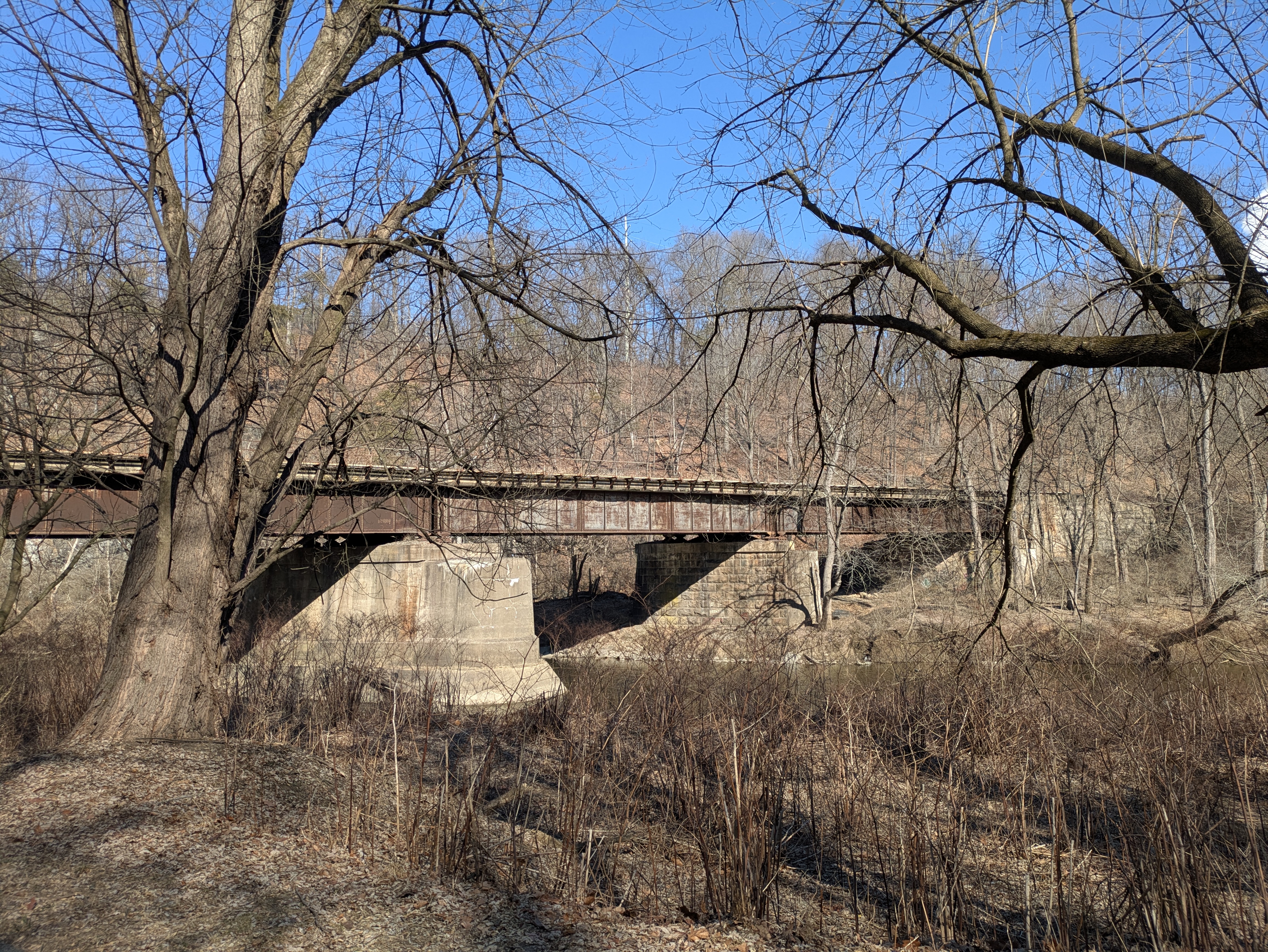
Black Bridge carries CSX freight to and from York


One of the things I love about the York Heritage Trail is that it follows active rail lines for much of its length. York City is served by Norfolk Southern and CSX both being essential freight lines that carry product and materials to and from the busy industrial fringe and heart of this once powerful manufacturing center. During the late 1800s and early 1900s no less than five rail lines utilized this valley including two trolley lines, two standard gauge railroads, and a narrow gauge railroad. I was hoping a Saturday train might come through but I guess they have weekends off. 


Ardent Flour Mills

The hum of the busy Ardent Flour Mills across the creek reminded me of how important this creek was to the dozens of mills that operated along these banks in the 1800 and 1900s. The bridges that crossed the Codorus out of York were in the crosshairs of Confederate raiders who, in June of 1863, blew up the Black Bridge to disrupt rail traffic and isolate the milling district that contained essential materials the southern army needed. Though the North Central Railway repaired the bridge within days, Black Bridge was placed under armed guard for the duration of the war. The North Central Railway was a prime target for General Early's raiders and the company lost twelve bridges between the Maryland Line and York. All were swiftly rebuilt by railroad workers but the constant threat of further attacks hung heavy along this creek. 

Cascade of Partridge Berry

Frost-curled fern

 
Flood levied and straightened Codorus Creek


Coming into the more industrialized northern edge of York City, the wild creek valley suddenly becomes an engineered flood-prevention project with levies and stripped banks. This is the start of a four-mile section of Army Corps of Engineers projects that began in the 1930s to prevent damaging floods from destroying industries, commerce, and neighborhoods. The project continues its upgrades and improvements to flood walls, a dam, upstream reservoir, and rip-rap diversions/banks in what seems to be a never ending years-long refurbishment of this aging flood control system. 

Urban eagles nest here

An active nest

Just before the parking area on Loucks Mill Road where I left the truck, we passed an active bald eagle's nest where I was able to see a sitting female and an attentive male nearby. Most eagle pairs have by now laid at least one, possibly two eggs, and are awaiting hatching. Their presence in this wild pocket of flood plain forest surrounded by industrial lands and busy roads is a good sign for the recovery of Codorus Creek as a reliable fishery. It wasn't too long ago that this creek was overwhelmed by industrial waste water and sewage. The creek was dead. Fifty years on and it is a success story for the urban wilds. 

The wild side.

I was surprised by how much wildlife Amos and I saw and heard on this little 5-mile O&B. Red Foxes, Red-Tailed Hawks, Mergansers, Mallards, all the Woodpeckers, Killdeer (lots of those on the flood control banks), Robins, White-Tailed Deer, a Meadow Vole, Great Blue Heron x 5, Grey Squirrels, and (my favorite) an American Mink, filled my species list. Never mind that Amos YELLED at the Red Fox (who cared less on the opposite bank) until he went hoarse, this little sanctuary at the edge of the city was full of life ready for spring. 

Notes:

Black Bridge and other North Central Railway bridges suffered damage during General Jubal Early's raids in June 1863 in preparation for General Lee crossing the Confederate Army into Pennsylvania. https://yorkblog.com/cannonball/rebel-destroy-the-codorus-brid/